
How to research valley flow at a new take-off?
Valley winds are a type of wind pattern that can occur in areas with large topographic features such as mountains or valleys. These winds are caused by the differences in temperature and pressure between the air at the bottom of the valley and the air at higher elevations.
During the day, the air at the bottom of the valley tends to be warmer and less dense than the air at higher elevations. This can create a thermal updraft, or rising column of air, that can be used by paragliders to gain altitude. Valley winds can also be created by the cooling of the air at the bottom of the valley at night, which can cause the air to sink and create a downdraft.
Valley winds can be strong and gusty, and can create lift or sink for paragliders. These winds can also be turbulent, and can be difficult to predict.
As a paragliding pilot, it is important to be aware of valley winds and how they can affect your flight. These winds can create strong lift or sink, and can also be gusty or turbulent. It is important to fly cautiously and avoid flying too close to the sides of the valley, as the wind patterns can be unpredictable and can create dangerous flying conditions. It is also a good idea to seek the guidance of an experienced instructor or pilot if you are not familiar with flying in valley wind conditions.
Global weather systems
In this article, I will show you how I go about doing my home-work before I head out to fly in a new place. To me the most important part about flying in mountains, is to understand how the local valley system flow or the local valley winds work. No matter what the meteo wind dose, the valley flow will always be there, some days more some days less. In some areas in Alps it is crucial to know this before taking-off, as the wind straight can be really strong.
First things first I look at the big picture, I always start from zoomed out point of view.
Let me explain.
We have to understand the basics of how the air moves around the mountains before we go into details of each specific flying site. There are many articles going into detail about it and I am not going to try to repeat them here.
Here’s the outline of the process.
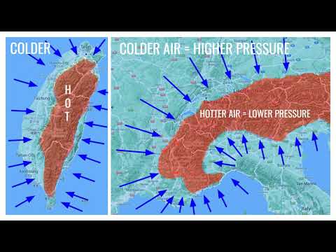
As the sun comes around in the morning the first sun rays reach the tops of the mountains. Mountains get heated before the flats or near by water bodies will. As the air around the peaks are warmed up it starts to rise, this rising air needs to be re-placed by something, by rising up it starts to pull the surrounding air towards the tallest peak.
This is what creates the valley flow or the valley breeze. Same thing happens in the evening as the peaks cool down first (higher altitude usually means lower temperature) the air starts to slide down from the mountains towards the valley, this creates the mountain breeze. Also know as the Anabatic and Katabatic wind flows.
If there is any water near by, remember that it takes longer time for water to heat up comparing the ground or mountains, this is why we get sea breeze.
Local systems

How would I go about it to do my research for the take-off area Chabre near Laragne Monteglin?
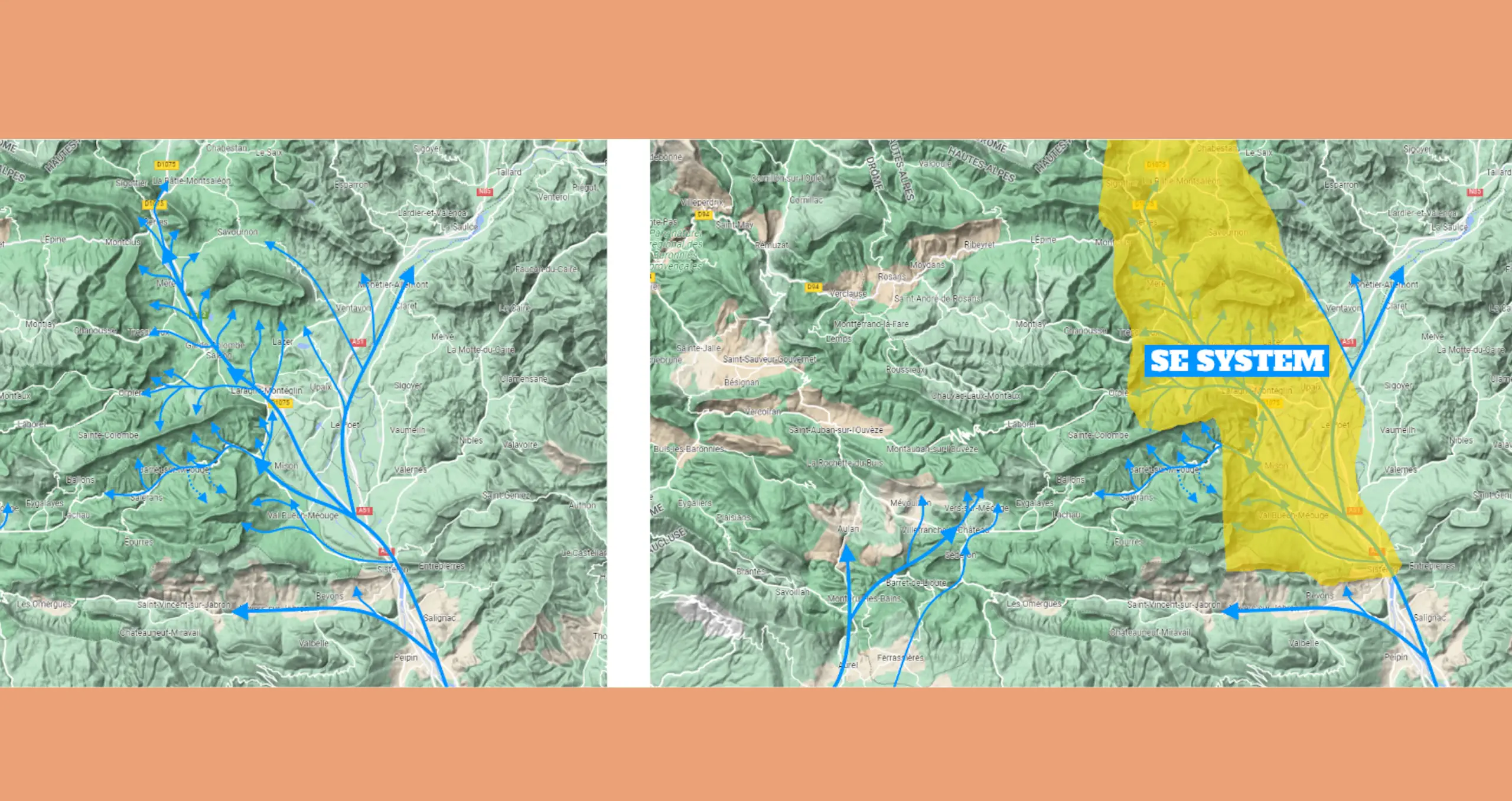
I start with the large scale, in this case the French Alps.
This area is located to the West of the main alpine ridges of France. West of Chabre there are the flat lands, to the South you have the sea and to the East the high mountains of the Alps. These large systems interact with each other here on daily basis.
The Alps will heat up first and will be pulling air towards them. For the air to affect Chabre, it will have to pass the physical blocks South and West of Chabre before it will affect the local micro conditions at the take-off.
Naturally the air will follow the route of least resistance, which means it will flow first though the larger openings, that are not blocked by large terrain changes.
As indicated in the video above.
As with global scale or large scale, same is true fore micro levels. Wind will always try to follow the route of least resistence.
Micro system
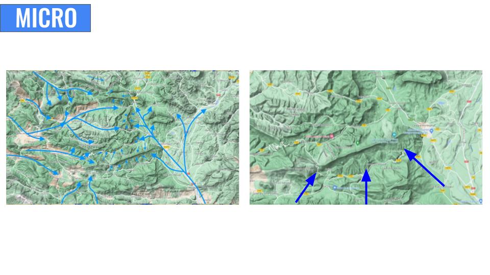
As with macro systems so with micro, the air will go from lower heights to higher heights. The Chabre ridge is situated from ENE to WSW dirrection, it’s main face is orientated towards SSE. Sun heats up the top of Chabre sooner than it will do the surrounding valley floor. Which makes temperature differences and this will start creating local micro climate with valley winds being pulled to nearest highest peak.
As the day progresses, the larger scale system will be taking over. In this case the Alps on the East will be gaining energy and pulling air towards them, and the air at the flats on the West side of Chabre will start moving towards East, creating a Westerly breeze later on in the day locally for the Chabre take-off.
As indicated in picture above, Chabre on a normal day without large meteo systems it will start the day with SE winds. It will move to South winds and eventually become SW and westerly winds.
This happens because the larger system takes over the weaker local system.

Re-searching other pilot flights.
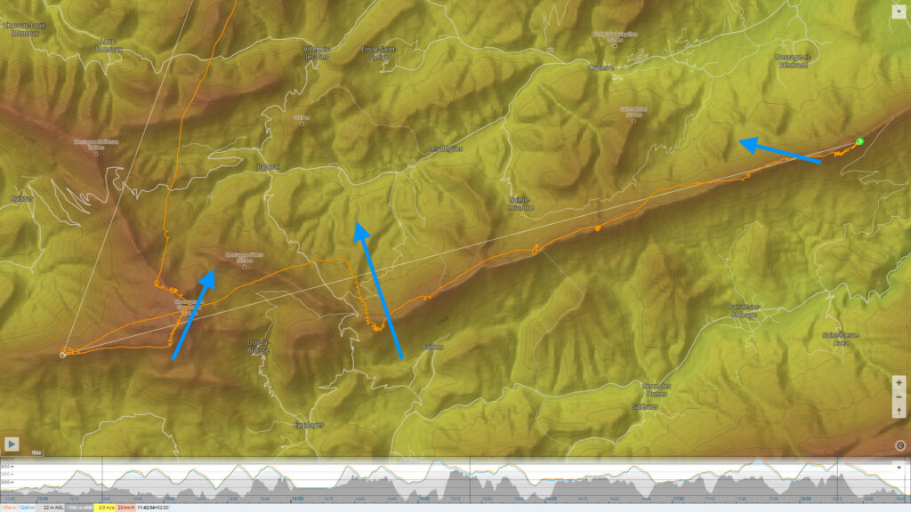
Below in the picture of a flight log done from Chabre, you can see that early in the flight the thermal drift indicates SE wind as the pilot moves more towards West it became SSE and later on it turns SW dirrection. This is influence by the local system and by the Westerly system as you move more West of Chabre the more westerly component you will tend to get.
Understanding the basic concepts of how the valley systems works help you to understand other pilots flights. By looking at what other pilots have done on any given site can give you a very good idea what works for that site.
I like to check some 15-30 flights done from a site in the time of the year that I intend to fly there. As seasonal changes also affects how much valley flow we can expect.
If you go to XContest.org website and check what people have done from Chabre, you will soon realize that there is a pattern to it.
In the video above you can see how it is possible to use the local valley winds to your advantage. By knowing how the winds change during the day you can then adapt your plan and make your flying more efficient and easy.
If you want to explore further away the take-off you have to look how that area works at the time of the day you plan to be there. Like in the example above, knowing that there will be North component later in the day, I used that to come back towards the take-off and flew most of the flight with some tail wind. Making it easier for me to achieve longer distance.
Knowing the local systems and how they interact is what I based the Chabre Challenge on.
For Chabre, the westerlies will get stronger as the day progresses, so it makes a lot of sense to start the flight towards west and later move toward North and eventually east. This way you use the local valley flow in your favor to fly as far as the day allows you do do so.

To have a de-tailed flight plan for Chabre Signe up for my e-mail list and you’ll receive a pdf with instructions. If you like to have more flight plans please consider buying the Guide to Chabre book or the pdf.
